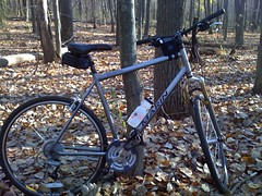
Not exactly the ideal ride for a technical mountain biking course, but my Marin San Anselemo hybrid did just fine on this weekend's ride. I'm a road cyclist, and don't intend to do too much more moutain biking, but had a great time trying it out this weekend at Yankee Springs State Recreation Area.
Monday, November 9, 2009
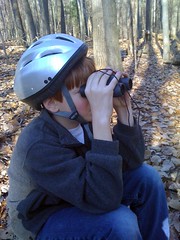
Alex Taking a Break from Mountain Biking
Alex needed a break after mountain biking over some pretty technical mountain bike trails at Yankee Springs State Recreation Area. Being the good Boy Scout, he brought a backpack with everything that you could possibly need including a pair of binoculars!
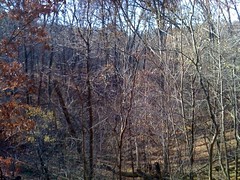
Devil's Soup Bowl
View from the ridge of Devil's Soup Bowl at Yankee Springs State Recreation Area. This 100 foot deep hole in the ground was created approximately 13,000 during the last ice age by glacial action. The picture doesn't do the glacial kettle justice as the woods have filled-in over time. This is the largest of several glacial kettles along the mountain bike trails in the park.
Mountain Biking at Yankee Springs State Recreation Area
My son, Alex, and I had a fabulous time this past weekend with his Boy Scout Troop exploring the mountain biking trails at Yankee Springs State Recreation Area.
The park has over 13 miles of mountain biking trails. In some areas, the ride was fairly technical. During our afternoon ride, we found ourselves riding along the ridge between deep glacial kettles--the biggest being the "Devil's Soup Bowl," which is approximately 100 feet in depth and very steep.
Name: Track 003
Date: Nov 7, 2009 10:03 am
Distance: 7.71 miles
Elapsed Time: 2:07:29
Avg Speed: 3.6 mph
Max Speed: 19.2 mph
Avg Pace: 16' 32" per mile
Min Altitude: 0 ft
Max Altitude: 996 ft
Start Time: 2009-11-07T15:03:40Z
Start Location:
Latitude: 42.623786º N
Longitude: 85.469502º W
End Time: 2009-11-07T17:11:10Z
End Location:
Latitude: 43.011992º N
Longitude: 86.173588º W
Click on this link to display the track in Google Maps. This link will be valid until Dec 9, 2009 2:07 PM PST.
The weather was as perfect as you could ask for in early November. The leaves were off the trees, and there were only a few other hardy souls camping in the park, which gave it a spooky feeling especially when the coyotes started to howl late at night.
I'll post some pictures in the next blog post.
Monday, October 26, 2009
MotionX-GPS Track: Track 001
Hello,
Craig uses MotionX-GPS on the iPhone 3G or 3GS and is sharing with you the following track:
| Name: | Track 001 |
| Date: | Oct 26, 2009 2:29 pm |
| Distance: | 0.39 miles |
| Elapsed Time: | 09:01.3 |
| Avg Speed: | 2.6 mph |
| Max Speed: | 4.7 mph |
| Avg Pace: | 23' 22" per mile |
| Min Altitude: | 535 ft |
| Max Altitude: | 556 ft |
| Start Time: | 2009-10-26T18:29:26Z |
| Start Location: | |
| Latitude: | 43.015735º N |
| Longitude: | 86.177367º W |
| End Time: | 2009-10-26T18:38:28Z |
| End Location: | |
| Latitude: | 43.011805º N |
| Longitude: | 86.173115º W |
Click on this link to display the track in Google Maps. This link will be valid until Nov 25, 2009 12:25 PM PST.
There are two files attached to this email:
"Track 001.kmz" is a Google KMZ track that can be displayed in Google Earth or Google Maps.
"Track 001.gpx" is an Open Standard track that can be displayed by select mapping software.
MotionX-GPS Commonly Asked Questions:
| Q1: | What is MotionX-GPS? |
| A1: | MotionX-GPS, available for the iPhone 3G and 3GS, is the essential application for hikers, bike riders, joggers, and geocaching enthusiasts. It puts an easy-to-use, state-of-the-art handheld GPS system on your iPhone 3G or 3GS. |
| Q2: | Can I use MotionX-GPS? |
| A2: | Sure! MotionX-GPS Lite for the iPhone 3G and 3GS is free and can be downloaded from the iTunes App Store here. |
| Q3: | How can I display tracks in Google Earth? |
| A3: | Follow the directions on the Google Earth web site to download and install the Google Earth program. Save the attached Track 001.kmz file to your computer. Launch Google Earth, select File, Open, and open the saved Track 001.kmz file. |
| Q4: | What is a GPX Track? |
| A4: | GPX stands for GPS Exchange Format and is used to transfer GPS data between many GPS devices and applications, including Google Earth. A track is a path recorded by MotionX-GPS showing movement over the surface of the Earth. |
| Q5: | This e-mail was forwarded to me and I can't find the attachments! |
| A5: | Some e-mail programs do not include the original attachments by default when forwarding an e-mail. In this case, the sender must reattach the original files for them to be included. |
Please contact us here with any comments or questions.
All the best,
The MotionX Team
US and Foreign Patents Granted and Pending. Fullpower® is a registered trademark of Fullpower Technologies, Inc. MotionX™ is a trademark of Fullpower Technologies, Inc. © Copyright 2003 - 2009 Fullpower Technologies, Inc. All rights reserved.
ver: GPSLite/7.2 ver: com.fullpower.motionx.gps.web.Version@e9697ea4; ref-id: 65f6e4d5-5beb-4576-8641-c493af10988d
Wednesday, September 16, 2009
Apple Cider Century Just Around the Corner

I am registered to ride in the Apple Cider Century taking place on Sunday, September 27th in Three Oaks, MI. The ride is the largest one-day ride in the Midwest with 5,000 riders registered this year. This is my first time riding in the ACC. This is the first organized ride I am doing without my cycling buddies--should be interesting!
Saturday, July 25, 2009

Subscribe to:
Posts (Atom)