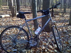
Not exactly the ideal ride for a technical mountain biking course, but my Marin San Anselemo hybrid did just fine on this weekend's ride. I'm a road cyclist, and don't intend to do too much more moutain biking, but had a great time trying it out this weekend at Yankee Springs State Recreation Area.
Monday, November 9, 2009
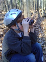
Alex Taking a Break from Mountain Biking
Alex needed a break after mountain biking over some pretty technical mountain bike trails at Yankee Springs State Recreation Area. Being the good Boy Scout, he brought a backpack with everything that you could possibly need including a pair of binoculars!
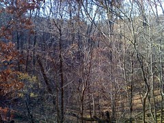
Devil's Soup Bowl
View from the ridge of Devil's Soup Bowl at Yankee Springs State Recreation Area. This 100 foot deep hole in the ground was created approximately 13,000 during the last ice age by glacial action. The picture doesn't do the glacial kettle justice as the woods have filled-in over time. This is the largest of several glacial kettles along the mountain bike trails in the park.
Mountain Biking at Yankee Springs State Recreation Area
My son, Alex, and I had a fabulous time this past weekend with his Boy Scout Troop exploring the mountain biking trails at Yankee Springs State Recreation Area.
The park has over 13 miles of mountain biking trails. In some areas, the ride was fairly technical. During our afternoon ride, we found ourselves riding along the ridge between deep glacial kettles--the biggest being the "Devil's Soup Bowl," which is approximately 100 feet in depth and very steep.
Name: Track 003
Date: Nov 7, 2009 10:03 am
Distance: 7.71 miles
Elapsed Time: 2:07:29
Avg Speed: 3.6 mph
Max Speed: 19.2 mph
Avg Pace: 16' 32" per mile
Min Altitude: 0 ft
Max Altitude: 996 ft
Start Time: 2009-11-07T15:03:40Z
Start Location:
Latitude: 42.623786º N
Longitude: 85.469502º W
End Time: 2009-11-07T17:11:10Z
End Location:
Latitude: 43.011992º N
Longitude: 86.173588º W
Click on this link to display the track in Google Maps. This link will be valid until Dec 9, 2009 2:07 PM PST.
The weather was as perfect as you could ask for in early November. The leaves were off the trees, and there were only a few other hardy souls camping in the park, which gave it a spooky feeling especially when the coyotes started to howl late at night.
I'll post some pictures in the next blog post.
Subscribe to:
Posts (Atom)